Flood Mapping Updates
Flood Map Information
The link below will take you to the flood map changes viewer. This viewer provides a single location to access flood hazard data and facilitate a better understanding of potential changes coming to flood hazard risks.
https://fema.maps.arcgis.com/apps/webappviewer/index.html?id=e7a7dc3ebd7f4ad39bb8e485bb64ce44
Flood Update Summary
FEMA is updating flood mapping documents in surrounding counties, including Kettering. The maps and related information guide development to reduce flood impact and to assign risk for insurance purposes. The primary impact to certain Kettering property owners will be potential development restrictions and possible requirement of flood insurance by mortgage companies. The specific documents being updated are the Flood Insurance Study and Flood Insurance Rate Maps (FIRMs).
Explanation
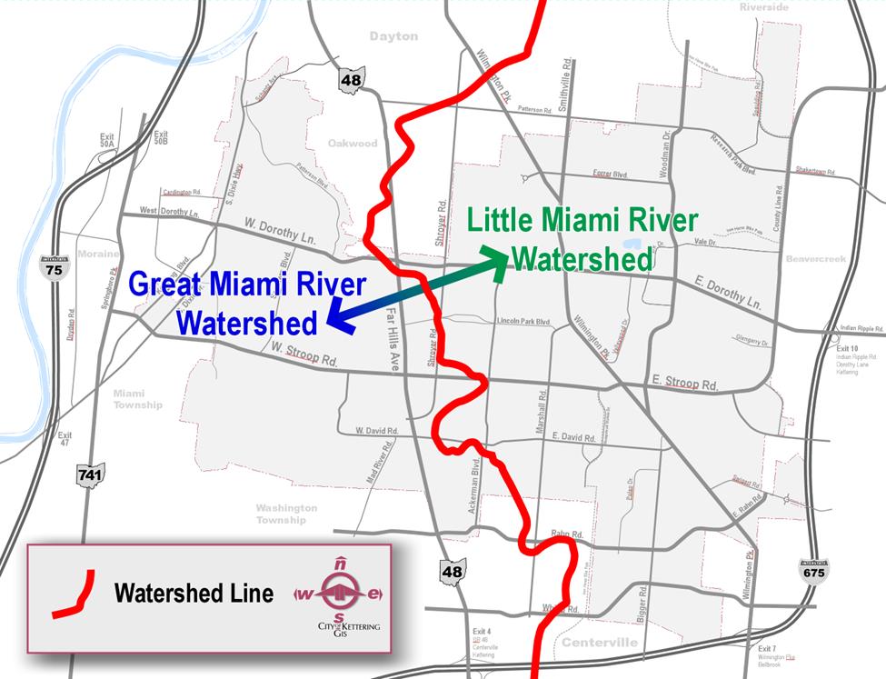
Kettering drains in two directions: to the Great Miami River on the west and to the Little Miami River on the east. The Great Miami Watershed is under study, and maps are planned to be updated in the next several years. The Little Miami Watershed has been studied and maps became effective March 8, 2022 for Greene County and October 27, 2022 for Montgomery County.
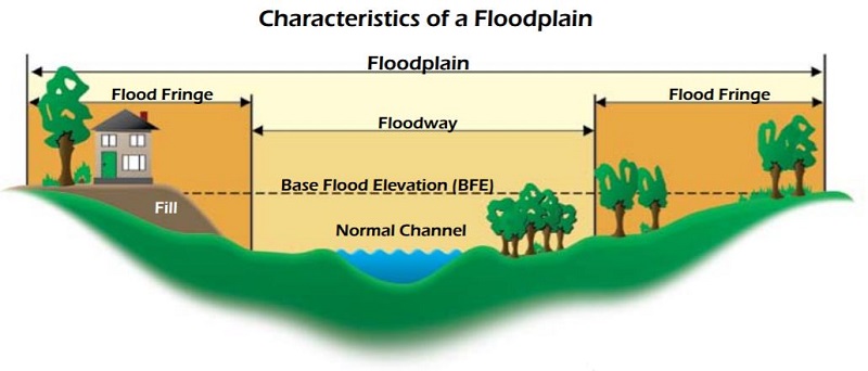
The new maps were created using more advanced and accurate technology to determine the land form. The analysis identifies waterways and projected elevations during flood events. The four key technical terms when evaluating flood maps are Floodplain, Floodway, Flood Fringe and Base Flood Elevation.
The Floodway can be understood as a waterway swelling up to overflow the banks. Development in the Floodway is essentially prohibited by the City’s Flood Damage Prevention Ordinance.
The Floodplain can be understood as the area where stormwater overtops the banks of the waterway, including the Floodway, and floods the surrounding lowlands as shown in the below graphic. The Flood Fringe portion of the Floodplain is an essential part of the waterway that stores substantial amounts of water until the flood waters recede. The Floodplain is determined by identifying a storm of certain magnitude (a severity of storm with a 1% chance of happening in any one year) and then calculating the anticipated height of flood waters–the Base Flood Elevation. To determine this storm event, historical storm information is applied with the intensity and duration of the precipitation. The term 100-year storm was previously used, but this nomenclature has been abandoned by FEMA due to confusion on the perceived frequency of significant flooding events.
Development in the Flood Fringe is permitted with the restrictions that it will neither cause a substantial negative impact to the flow of flood waters nor cause significant damage to a structure.
To protect their investment, mortgage companies typically require flood insurance for properties with structures in the Floodplain. The rates for flood insurance vary by risk. To put this in perspective, the average cost for flood insurance in Ohio is $1,225 per year. For properties in low-risk areas, the cost can be as low as $200 per year.
Kettering participates in the National Flood Insurance Program Community Rating System. This effort reduces risk for flood damage and, in return, qualifies property owners for discounts on flood insurance.
The map below shows the Floodplain (shaded light blue), Floodway (diagonal red hatching over shaded light blue), Flood Fringe (shaded light blue with no diagonal red hatching), and Base Flood Elevations (xxx FEET with squiggly lines denoting the extent of the Floodplain).

The newer maps, which were created with more accurate information and modeling techniques, show modified Floodway and Floodplain areas for certain neighborhoods in Kettering. Some properties that were not previously shown in the Floodplain will be soon, and vice versa. If a property is newly classified in the Floodplain, the property owner may wish to hire a surveyor to determine the lowest adjacent grade at the structure and compare that to the Base Flood Elevation. If the lowest adjacent grade is higher than the Base Flood Elevation, the property owner would typically apply to FEMA for a Letter of Map Amendment (LOMA). Upon receiving the approved LOMA, a mortgage company is likely to waive its requirement for flood insurance. The property owner can still obtain flood insurance, but likely at a reduced rate.
If an owner does not have a mortgage or other type of loan against the property, then flood insurance may not be immediately required if the it is located within the Floodplain. However, when the owner goes to sell the property or attempts to obtain an equity loan from a bank, obtaining flood insurance would likely be a condition of the mortgage or loan.
FEMA has requested Kettering assist with communicating this map updating process to the community and particularly impacted property owners who may not be aware of the flood hazard to their structures.
Engineering (937-296-2436) and Planning & Development (937-296-2441) staff regularly assist property owners with flood plain concerns and will continue to do so as the new flood maps become effective in 2022. A similar update to the FEMA flood maps last occurred for Kettering in Montgomery County in 2005.
To research flood risk at a specific property, go to https://msc.fema.gov/portal/search